
Ziarat
Ziarat District, Balochistan
On video
Quetta and Ziarat — Road Trip, Ziarat City and Quaid-e-Azam Residency by WildShots By AJ on YouTube. Not ours, and not an endorsement — it is the clearest look at the drive and the valley we could find.
Ziarat is a hill town at about 2,400 metres in Balochistan, 130 kilometres from Quetta, standing in the largest juniper forest in Pakistan — trees that run to four thousand years old. It is also where Muhammad Ali Jinnah spent the last months of his life.
Weather at Ziarat
Up at 2,498 m: 10.4°C there now, clear. Over the next 24 hours 3.6°C to 13.4°C.
This is the weather at Ziarat, not a road report — whether the road is open depends on ploughing, landslides and local decisions no forecast knows about, so check before you set off. Forecast from MET Norway, CC BY 4.0.
What it costs to drive there
| From | Distance | Driving | Petrol |
|---|---|---|---|
| Islamabad | 823 km | 10.7 h | Rs 22,300 |
| Rawalpindi | 821 km | 10.8 h | Rs 22,200 |
| Lahore | 794 km | 11.3 h | Rs 21,500 |
| Karachi | 806 km | 9.8 h | Rs 21,800 |
| Peshawar | 842 km | 11.6 h | Rs 22,800 |
| Multan | 465 km | 7.7 h | Rs 12,600 |
A car doing 12 km/l at today’s Rs 325.00/litre. Open a row to work it out for your own car, your own speed and with the air conditioning on — or see every distance from Ziarat.
What it is
A town and district headquarters in Ziarat District, about 2,400 metres above sea level and 130 kilometres from Quetta. It was part of Sibi District until it was made a separate district on 1 July 1986.
The climate is continental and the town stays genuinely cool through the summer, which is the whole reason the British developed it and the reason people drive up from Quetta now. The district also lives off apple and cherry orchards, and has the highest Human Development Index of any district in Balochistan.
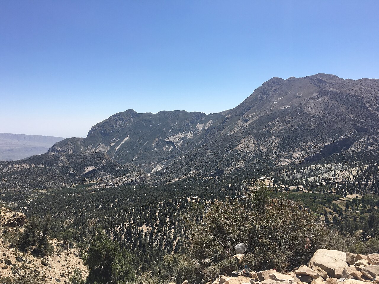
The juniper forest
The town is surrounded by the Ziarat juniper forest, known locally as sanober — the largest stand of Juniperus seravschanica in Pakistan, covering about 110,000 hectares, and believed to be the second largest juniper forest of its kind in the world.
Some of these trees are around four thousand years old. That is the single most remarkable thing in the valley and the easiest to drive past without registering.
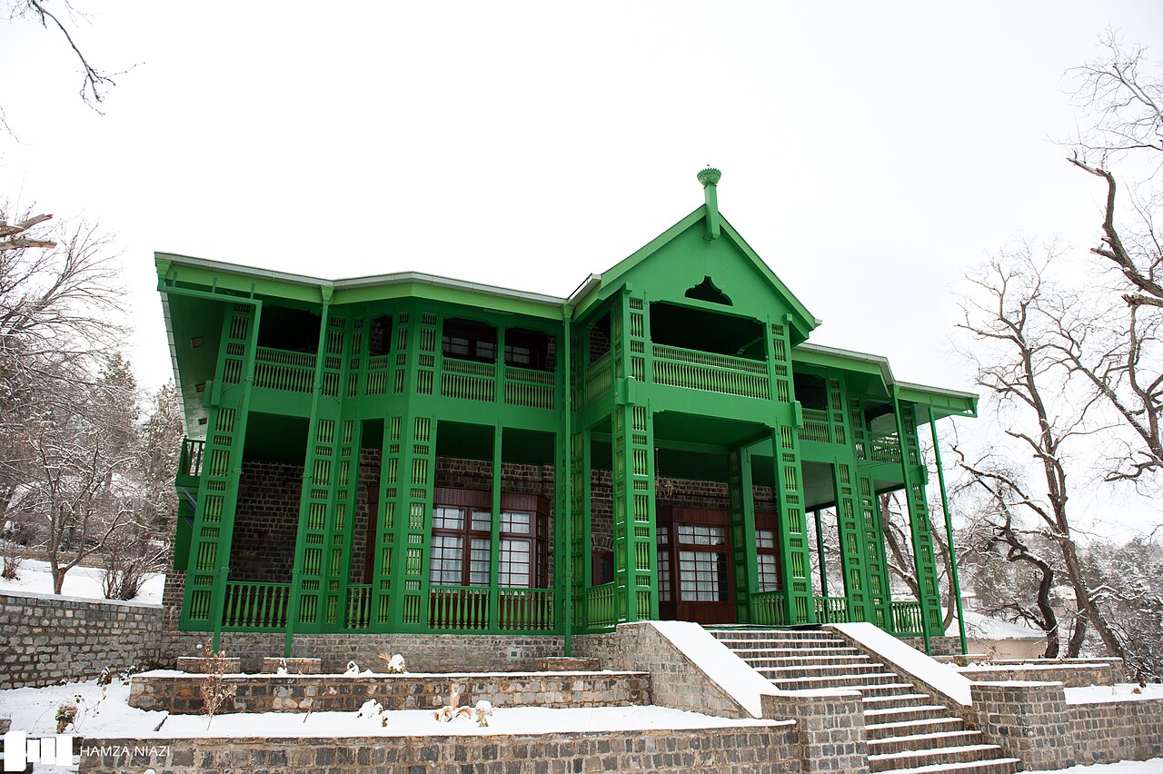
The Residency
The Quaid-e-Azam Residency is a two-storey wooden building put up by the British in 1892, originally as a sanatorium — the dry mountain air was thought good for lung disease — and later used as the summer residence of the Agent to the Governor-General of Balochistan.
In mid-1948 Jinnah's tuberculosis, concealed for years, had worsened sharply. On medical advice he was moved from Karachi to Quetta on 6 July 1948 and shortly afterwards up to Ziarat. He stayed in the Residency with his sister Fatima Jinnah, who took the room facing his on the upper floor. He died that September.
The building was attacked and burned down in 2013 and has been rebuilt.

The 2008 earthquake
At about four in the morning on 29 October 2008 Ziarat and the area around it were hit by an earthquake doublet: a 6.2 tremor lasting a couple of seconds, then a 6.4 lasting almost thirty.
Mud houses and several government buildings were destroyed, more than 200 people were killed and over 50,000 were left homeless. Landslides cut the roads, and helicopters were used to reach the mountain villages. It is part of why so much of what you see here is new.
What there is to see
- Quaid-e-Azam Residency
- The 1892 wooden building where Jinnah spent his last months, rebuilt after 2013.
- The juniper forest
- About 110,000 hectares, with trees said to be four thousand years old.
- The orchards
- Apples and cherries through the valley — the other thing Ziarat lives on.
- Khalifat Hills
- The highest peak in the district at 3,500 metres.
- Quetta
- 130 km away, and where the drive up starts.
When to go, and when not to
April to October, and summer above all — the point of Ziarat is that it is cool when the rest of Balochistan is not. Apple and cherry season through late summer is the best of it.
Winter is cold and snowy at 2,400 metres and the road up from Quetta can be difficult. This is also a part of the country where the security position is worth checking before setting a date, rather than assuming.
Where this comes from
- Ziarat — Wikipedia — The 130 kilometres from Quetta, the 1986 separation from Sibi, the juniper forest and its 110,000 hectares and four-thousand-year-old trees, the continental climate, and the October 2008 earthquake doublet and its toll. Written from it, not copied; Wikipedia is CC BY-SA 4.0.
- Ziarat District — Wikipedia — The 2,400-metre altitude, the Khalifat Hills at 3,500 metres, and the orchards and Human Development Index.
- Quaid-e-Azam Residency — Wikipedia — The 1892 construction and sanatorium origin, the colonial use, and Jinnah's move from Karachi on 6 July 1948 and his stay with Fatima Jinnah.
- OpenStreetMap — Road distances and driving times, via OSRM.